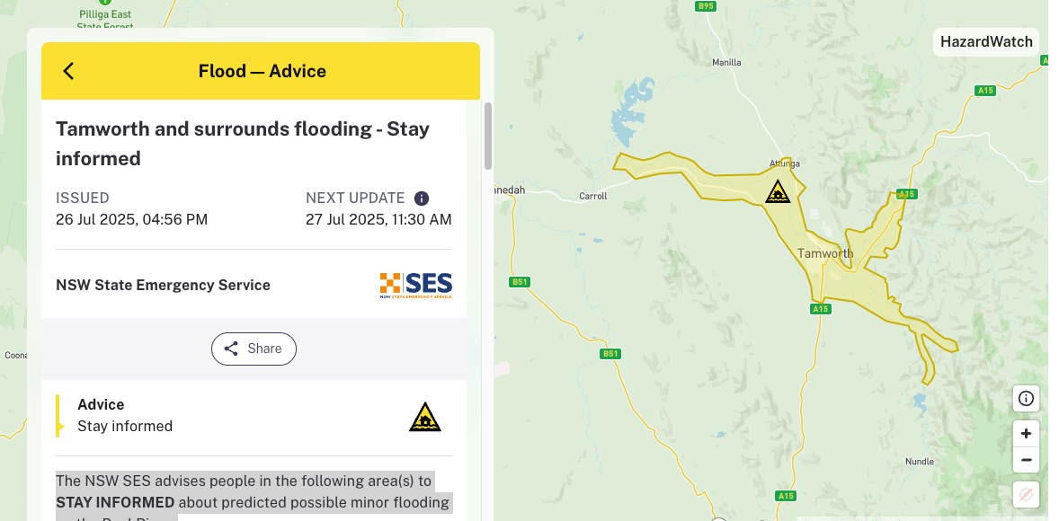
The first of what is expected to be a number of minor flood warnings has been issued, with the SES and Bureau of Meteorology warning about low level flooding and road closures in Tamworth.
Widespread rainfall of 10-25 mm has been recorded in the Peel River catchment over the last 12 hours which has caused river level rises along the Peel River and its tributaries, with minor flooding possible at Tamworth.
As at 4.25pm on Saturday, the Peel River at Tamworth is at 1.10 m and rising, below the minor flood level. The Peel River at Tamworth may reach around the minor flood level (3.00 m) overnight Saturday into Sunday.
The NSW SES advises people in the following area(s) to STAY INFORMED about predicted possible minor flooding on the Peel River:
- Low lying areas along the Peel River and its tributaries
Based on predictions from the Bureau of Meteorology, the following areas may be impacted by dangerous floodwaters:
- Wallamore Road between Jewry Street and Evans Street closed in both directions
- Warral Road near Impala Estate Road, road closed in all directions
- Kia Ora Lane, road closed in all directions
- Duri-Dungowan Road at Gowrie Road, road closed in all directions
- Low lying areas along the Peel River
Rain is predicted to continue all week across the region as an extremely large weather system makes its way across the country.
Severe Weather Update 26 July 2025: Wind and rain easing this weekend but more rain approaching
Video current as of 11:30am AEST 26 July 2025.
For the latest forecasts and warnings, go to our website https://t.co/4W35o8iFmh or the BOM Weather app. pic.twitter.com/E9oivYmrhf — Bureau of Meteorology, Australia (@BOM_au) July 26, 2025
What you need to do:
You should stay informed by monitoring warnings issued by NSW SES on their website and Facebook page, listening to your local ABC radio station, and checking the latest weather information from the Bureau of Meteorology online.
- If you have a Home or Business Emergency Plan, follow it. Otherwise, have a conversation and plan for what you will do and take with you if you need to evacuate.
- Consider the consequences of road and bridge closures and water over roads and make alternate arrangements for work, children, and travel.
- Obey all signs about road closures and instructions from emergency services.
- Never drive, walk, ride through, play or swim in floodwater – it is dangerous, toxic, and may void your car insurance. If it’s flooded, forget it. Fines may apply.
- Avoid storm drains and pipes, ditches, ravines, creeks, and rivers.
- People in areas likely to be impacted by flooding should raise their assets, including waste and chemical containers above expected flood heights.
- Share this information with family, friends, and neighbours and help others prepare where possible.
- If you are likely to be isolated due to flooding, stock up on essential items now.
- People working or camping along the river should monitor river heights and be prepared to relocate to higher ground.
- Farmers should consider moving pumps and farm equipment to higher ground.
- Companion animals and livestock should be relocated to higher ground that will not become an island.
For more information:
- Listen to your local ABC radio station which can be found at reception.abc.net.au
- “Listen to [ABC New England North West 648AM]”
- Download the Hazards Near Me app and set your watch zones to get warning information for your areas.
- Follow us on social media @NSWSES or visit our website at www.ses.nsw.gov.au
- Learn about your risk at www.ses.nsw.gov.au/knowyourrisk
- Check latest weather, warnings, rainfall and river heights at www.bom.gov.au/nsw
- Check road closures at www.livetraffic.com.au or 132 701 or your local Council.